‘Super’ El Niño and San Diego – what scientists know now and what else they hope to learn
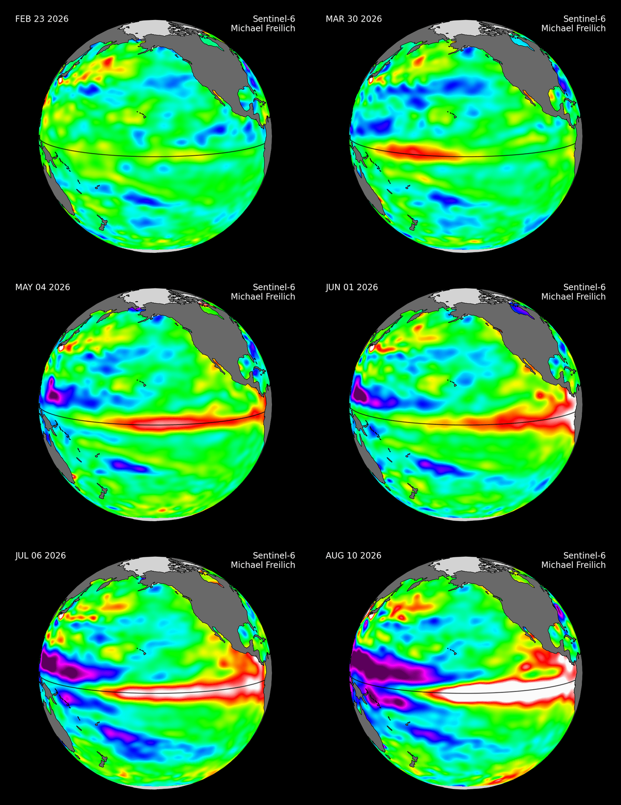
Gathering heat causes higher-than-normal sea surface levels in the Pacific Ocean due to El Niño from February 23, 2026 to August 10, 2026. Images captured by the Sentinel-6 Michael Freilich satellite. Data from NASA’s El Niño/La Niña Watch. Animation by Thomas Murphy.
As San Diego city workers prepare for a potentially historic “super” El Niño, some scientists say it’s still too early to tell if San Diego and Southern California are in for historic rainfall and flooding.
Scientists at UC San Diego’s Scripps Institution of Oceanography have been studying the formation of this El Niño. Researchers published a new, multi-part FAQ guide explaining what El Niño is, why this year’s event could be unusually strong and how scientists are tracking it.
For San Diegans, El Niño can mean more rain, bigger surf, coastal flooding and warmer ocean temperatures. But scientists say it’s still too early to know exactly what this year’s event will mean, particularly when predicting rainfall and flooding.
Historically, El Niño has increased the odds of wetter weather across Southern California, but the strength of an El Niño and actual rainfall in San Diego are not always intertwined.
One thing researchers do agree on is that forecast models reveal a moderate-to-large El Niño this year, with some suggesting it could be the largest in the 150-year historical record.
So, what exactly should San Diegans expect this year?
What is the El Niño-Southern Oscillation?
El Niño is a natural climate pattern that begins thousands of miles away in the tropical Pacific Ocean. When water near the equator becomes unusually warm, it can alter weather patterns around the world.
El Niño is one of two dominant weather patterns in the Pacific. While El Niño occurs when warm water builds up, the opposite pattern, La Niña, occurs when cooler water gathers in the region.
Southern California typically experiences drier conditions during La Niña. The two patterns are part of a larger climate cycle known as the El Niño-Southern Oscillation.
In the case of El Niños, rising temperatures weaken the east-to-west trade winds that normally push warm surface water westward across the Pacific. As those winds weaken, warmer waters remain and build up in the east. Higher ocean surface temperatures affect the air above, creating more intense storms.
“The tropics are like the engine room of the Pacific,” Shang-Ping Xie, a Scripps professor of climate science, wrote. “Heat in the tropics drives global atmospheric circulation. In that sense, variations in the tropical Pacific like El Niño can have huge impacts on global weather patterns.”
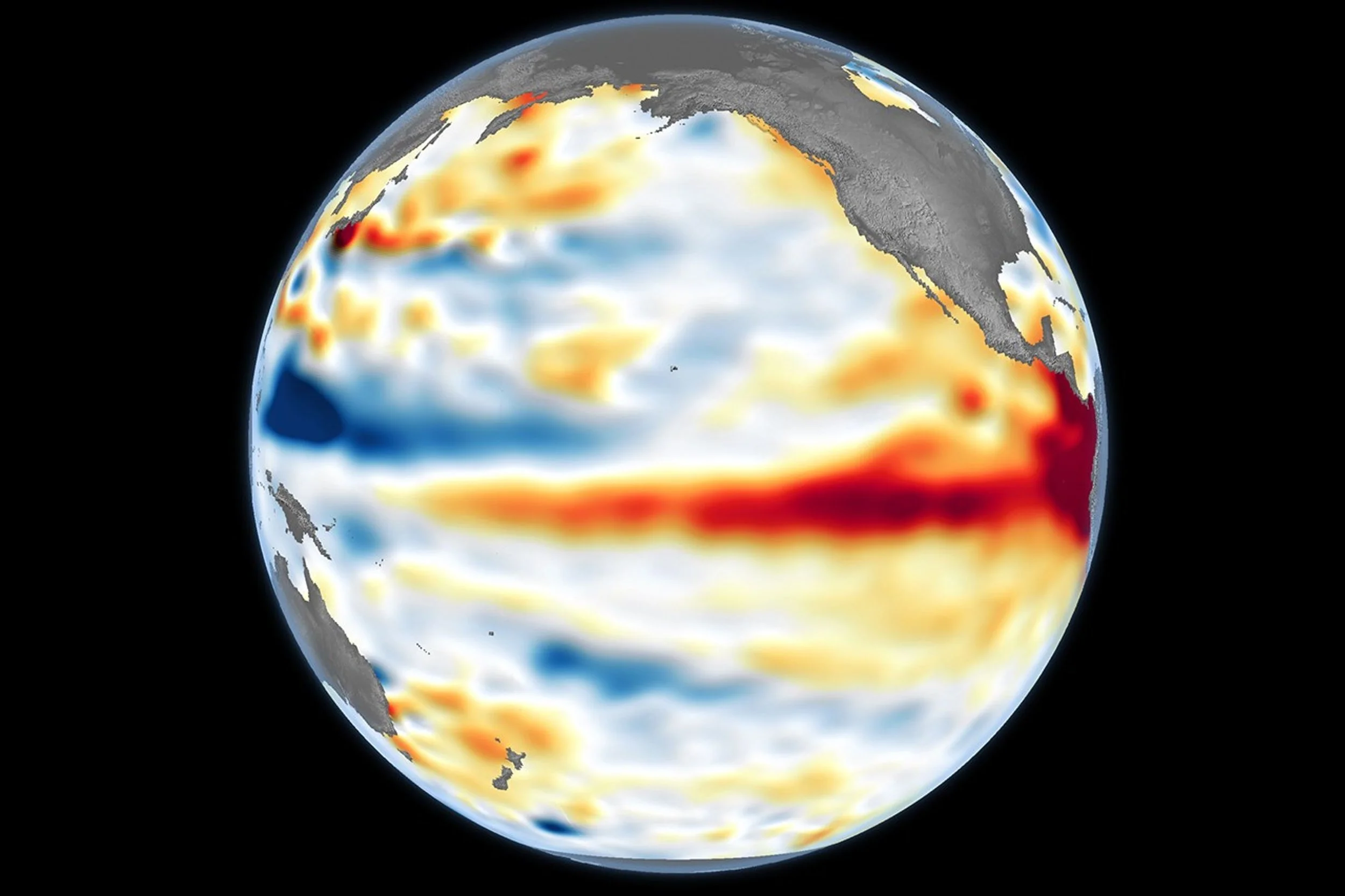
Higher-than-normal sea surfaces (red) are visible in the central and eastern Pacific on June 8, 2026, a few days before El Niño was declared. Data for the map were acquired by the Sentinel-6 Michael Freilich satellite and processed by scientists at NASA’s Jet Propulsion Laboratory (JPL). (NASA Earth Observatory/Lauren Dauphin)
One key measure is whether sea-surface temperatures in specific areas of the Pacific on the equator remain at least 0.9 degrees Fahrenheit above average. Those sea-surface temperatures are now what federal agencies are monitoring.
Sea-surface temperatures in the region are 3.6 degrees Fahrenheit above average, according to the National Oceanic and Atmospheric Administration, putting the odds of a very strong El Niño during fall and winter at greater than 90%.
While the presence of an El Niño is a certainty, its impact on Southern California and beyond is not as certain.
“It does not necessarily mean that the event will have a huge impact on our own weather in the U.S. during the upcoming fall and winter,” said Scripps researcher Art Miller. “Calling this a Super El Niño simply refers to the magnitude of the event in the tropical Pacific.”
More often than not, El Niños have resulted in stronger and more frequent winter storms for San Diego County.
“We’re keenly interested in this 2026-27 strongly developing El Niño because some previous strong cases, like the massive events in 1982-83 and 1997-98, were among the wettest years on record in California,” Scripps climate researcher Dan Cayan wrote.
“While we might partially attribute elements of individual storms to El Niño, we are left with statistical odds, rather than precise yes or no characterizations,” Cayan continued.
For residents along Chollas Creek in Southcrest — a neighborhood that suffered severe flooding during the January 2024 storms — another strong El Niño raises concerns that San Diego could see similar flooding again.
Preparations are already underway.
The Office of Emergency Services has formed an El Niño working group with representatives from city departments and public safety agencies to coordinate how the city prepares for storms, responds to emergencies and communicates with the public.
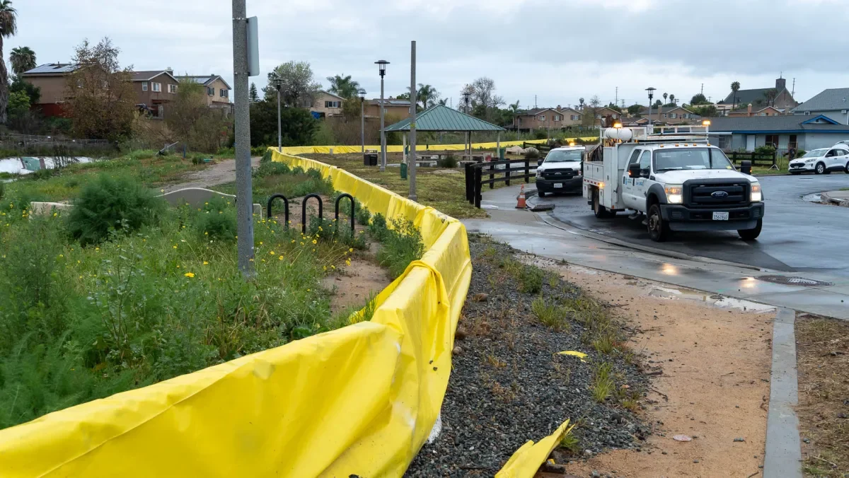
Flood barriers near Chollas Creek in Southcrest. The water level was elevated due to heavy rainfall on Feb. 16, 2026.
El Niño could bring coastal flooding without more rainfall
Potential heavy rainfall is not the only danger of the oncoming El Niño. Changes in ocean temperatures, waves and storm patterns can increase coastal flooding and accelerate erosion, particularly during high tides.
Scripps scientists will map California’s coastline before and after this year’s El Niño to monitor coastal changes and infrastructure damage.
Sea levels along the California coast can temporarily rise by as much as 13 inches during strong El Niño events, according to Scripps coastal geologist Adam Young, so this research can help predict how future sea level rise will impact the coast.
Those effects are occurring against a backdrop of unusually warm ocean temperatures. San Diego is already experiencing a marine heatwave, which led to dead seabirds lining beaches in March. This year has seen 42 record-high ocean surface temperatures at the Scripps Pier in La Jolla.
El Niño also sends subsurface waves along the coast that push warm surface water downward and suppress the normal upwelling of cold, nutrient-rich water. That can warm coastal waters while reducing the nutrients available to the base of the marine food web.
“Decreased vertical mixing can suppress nutrients from reaching the sunlit upper ocean, which fuels the base of the food chain and can thereby lead to less food availability for birds, sea lions, whales and other marine life,” Miller wrote.
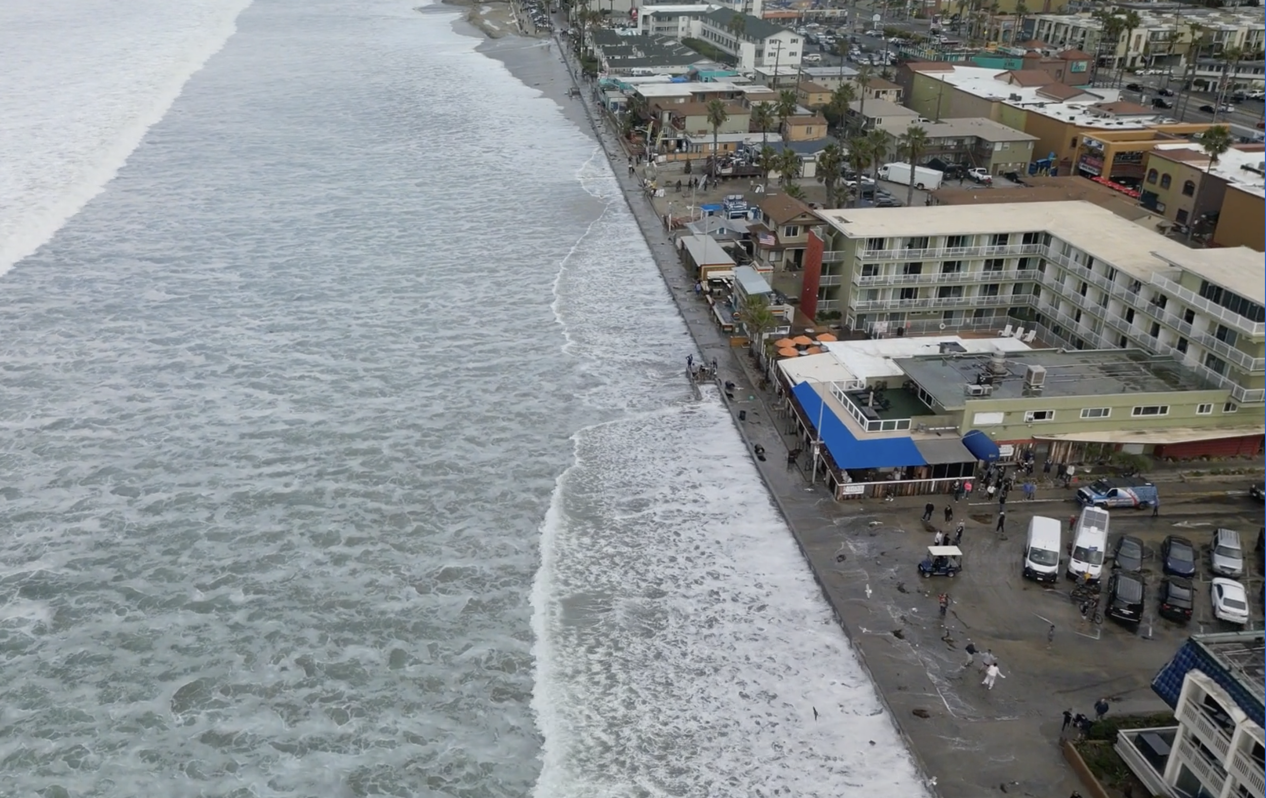
El Niño-amplified waves cover the beach and flood streets during a King Tide event in Pacific Beach, CA, on December 29, 2023. (Image courtesy of Scripps Institution of Oceanography)
What should San Diegans do now?
City officials recommend that residents make an emergency plan, prepare an emergency kit, sign up for emergency alerts and check whether their homes are in or near flood-prone areas.
These areas include Chollas Valley, Sorrento Valley, Mission Valley and the Tijuana River Valley, according to city maps.
The city says 15,000 acres and more than 6,900 structures are located in FEMA-designated flood-hazard areas. Officials also warn that flooding can occur outside those designated zones.
Residents should also know their evacuation routes and never attempt to drive or walk through floodwater.
The Office of Emergency Services has launched an El Niño preparedness webpage with information about flood risks, emergency preparation and alerts.
But it does mean there is enough uncertainty — and enough potential for extreme weather — that officials will continue preparing before the first major storm arrives.
» Originally published by Times of San Diego on August 25, 2026.